Confidentialité par la physique
Si vous ne voyez pas la caméra, la caméra ne vous voit pas. Pas un slogan — un fait optique.
Pourquoi la confidentialité dans les robots d'extérieur est importante
La plupart des systèmes autonomes d\'extérieur utilisent des caméras frontales ou des capteurs LiDAR qui capturent des environnements complets.
Ce ne sont pas des préoccupations hypothétiques. En février 2026, une violation a exposé comment plusieurs entreprises collectaient des données avec un consentement insuffisant.
Chaque incident partage une cause structurelle : les caméras frontales capturent des données d\'identité par conception.
Deux risques pour la confidentialité
Caméras frontales
Une caméra frontale capture tout dans son champ de vision : piétons, véhicules, structures, voisins.
La réponse de l\'industrie est l\'atténuation logicielle — chacune est contournable ou invalidée par les mises à jour futures.
La structure logique de « nous capturons votre visage mais le floutons immédiatement » est : faites confiance au logiciel, faites confiance à la politique, faites confiance à l'implémentation. Chaque lien de cette chaîne est un vecteur d'échec.
Cartographie LiDAR
Les capteurs LiDAR génèrent des cartes tridimensionnelles précises — pas seulement de la pelouse, mais des limites de propriété, empreintes de bâtiments, clôtures de voisins, véhicules dans les allées, fenêtres et zones de passage.
Contrairement aux images de caméra, les nuages de points LiDAR ne peuvent pas être anonymisés de manière significative. Pour les données de caméra, vous pouvez flouter les visages. Pour un nuage de points LiDAR d'un quartier résidentiel, il n'existe aucune opération comparable.
Si ces données sont stockées sur des serveurs dans des juridictions à faible protection des données, ou par des fabricants soumis à des demandes gouvernementales étrangères, la topologie de la propriété du client — et par extension les informations sur son mode de vie — devient exposée.
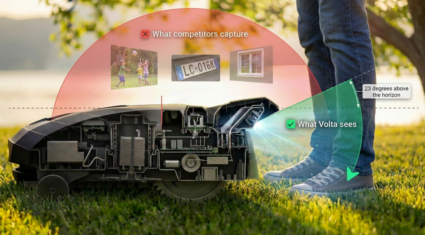
L'approche de Volta : la contrainte de 23 degrés
La caméra de The Lawn Companion est orientée vers le bas avec un champ de vision de 23 degrés. Elle voit uniquement la surface du gazon.
Ce n\'est pas un filtre logiciel. C\'est une contrainte physique. La caméra ne peut pas voir les visages.
La garantie de confidentialité ne nécessite pas de faire confiance au logiciel, à la politique ou au traitement des données de l'entreprise. Elle repose sur la physique de l'optique — vérifiable par toute personne pouvant voir l'orientation de la caméra.
Pourquoi 23 degrés ?
La limite de 23 degrés n'est pas arbitraire. C'est la réponse à une question d'ingénierie précise : quelle est l'enveloppe minimale du capteur qui préserve la confidentialité ?
- Fournit une vision avant suffisante pour la détection d'obstacles en temps utile
- Confine la capture à la surface du gazon et aux obstacles immédiats
- Tout ce qui est au-dessus de l'horizon est inutile pour la tâche
Les garanties de confidentialité logicielles nécessitent de faire confiance au fabricant.
Capturer tout et filtrer ensuite aurait été le choix d'ingénierie le plus simple. La contrainte existe parce que la confidentialité par la physique est plus robuste que la confidentialité par le logiciel.
Confidentialité matérielle vs logicielle
Minimisation logicielle traite les données capturées pour supprimer les éléments sensibles après numérisation — brouillage facial, suppression de plaques d'immatriculation, suppression temporisée.
Minimisation matérielle contraint les données entrant dans le système au niveau du capteur. Les données sensibles n'existent jamais sous forme numérique.
Pas de surface d'attaque sans fil
La garantie de confidentialité s'étend au-delà de l'optique. Le Lawn Companion n'expose aucun Bluetooth en fonctionnement normal. Le seul protocole sans fil est le Wi-Fi 802.11 b/g/n, utilisé exclusivement pour la communication avec la station de charge et la connectivité cloud.
La vulnérabilité Ecovacs — Bluetooth exploitable à 130 mètres, actif en permanence sur les modèles d'extérieur — n'a pas d'équivalent dans l'architecture de Volta.
Cloud sans surveillance
Le problème de confidentialité avec les robots d'extérieur connectés au cloud n'est pas la connectivité cloud — c'est quelles données sont transmises. Lorsque les données comprennent du LiDAR de quartier ou des images de caméras latérales, la connectivité cloud crée un risque de confidentialité proportionnel à la richesse des données.
Parce que la caméra de Volta ne capture que des images de gazon orientées vers le bas avec un champ de vision limité à 23 degrés, le flux de données transmis au cloud ne contient que des signaux agronomiques — pas d'informations personnelles identifiables.
Cela fait de la connectivité cloud un avantage agronomique — pas un risque de confidentialité :
- Apprentissage inter-propriétés. Les schémas observés sur des centaines de pelouses améliorent le modèle de tonte adaptative pour tout le monde.
- Intelligence saisonnière et régionale. Les données agrégées dans le cloud révèlent les tendances de croissance régionales et les schémas de stress climatique.
- Suivi de santé à long terme. Les données longitudinales permettent l'historique de santé au niveau de la propriété et la détection précoce de dégradation.
Le pipeline de données est propre dès la source. La confidentialité et l'intelligence cloud ne sont pas en tension quand la géométrie du capteur élimine les données sensibles en amont.
Meilleur pour la confidentialité — et meilleur pour votre pelouse
L'architecture de confidentialité n'est pas un compromis avec la capacité. L'orientation vers le bas est aussi le choix techniquement supérieur pour l'analyse du gazon :
- Résolution végétale plus élevée. Une caméra pointée vers le sol depuis moins de 20 cm capture le gazon à une résolution que les systèmes orientés vers l'avant ne peuvent pas atteindre.
- Meilleur rapport signal/bruit. Le cadre entier est le sujet d'analyse. Il n'y a pas de soustraction d'arrière-plan, pas de segmentation de scène, pas de bande passante computationnelle gaspillée.
- Meilleure détection de mauvaises herbes. L'identification des espèces de mauvaises herbes dépend de caractéristiques morphologiques fines : forme de feuille, motifs de nervures, détails de marge.
- Coût computationnel réduit. Ne traiter que le signal agronomique signifie une consommation d'énergie plus faible et une autonomie plus longue.
Le système est simultanément plus privé et plus performant — parce que la géométrie de vision optimale pour l'analyse du gazon est aussi celle qui élimine les voies de surveillance.
Ce que cela signifie pour votre maison
Les préoccupations de confidentialité sont une barrière documentée à l'adoption des systèmes autonomes d'extérieur. Les propriétaires s'inquiètent des robots qui cartographient leur propriété et transmettent des données.
Un système physiquement incapable de surveillance change la question de « Est-ce que je fais confiance à la politique de confidentialité de cette entreprise ? » à « Cette caméra peut-elle me voir ? »
Une garantie de confidentialité soutenue par la physique ne nécessite pas de comprendre l'architecture logicielle, d'évaluer la gouvernance d'entreprise ou de lire un document de politique. Elle nécessite de regarder la caméra et de noter qu'elle pointe vers le sol.
Confidentialité vérifiable
Si vous ne pouvez pas voir la caméra, la caméra ne peut pas vous voir.
Voir les plans